What Are the Best Scenic Drives Near Branson, Missouri?

Key Takeaways
- Thousand Hills Resort Hotel offers easy access to top scenic drives like Highway 165 and the Ozark Highlands Scenic Byway.
- The Highway 165 Scenic Overlook provides stunning views of Table Rock Lake and is close to Branson.
- Visitors can explore the Table Rock Lake Loop and enjoy outdoor trails at Ruth and Paul Henning Conservation Area.
- The Sugar Camp National Forest Scenic Byway allows for a quieter drive with beautiful forest scenery and access to Roaring River State Park.
- Peak fall foliage season occurs from mid-October to early November, making it an ideal time for scenic drives in the Ozarks.
Last Updated: April 2026
Thousand Hills Resort Hotel sits two blocks off Highway 76 in Branson, Missouri, placing six of the Ozarks’ top scenic drives within a 15-minute drive of the front desk. The Highway 165 Scenic Overlook, the 110-mile Ozark Highlands Scenic Byway on Route 86, and the Table Rock Lake Loop all start from routes that connect directly to the hotel’s location on South Wildwood Drive.
Guests who pair a morning drive with an afternoon round at the Golf Digest 4-star Thousand Hills Golf Course can fill an entire Branson weekend without repeating a single stretch of road. The hotel’s complimentary Famous Breakfast Buffet fuels early departures, and three on-site dining venues handle everything from quick Starbucks coffee at Shiloh’s Marketplace to a full sit-down dinner at Jack Henry’s restaurant.
Where Is the Highway 165 Scenic Overlook Near Branson?
The Highway 165 Scenic Overlook sits along Historic Highway 165 in Hollister, roughly five miles southwest of downtown Branson, Missouri. The overlook provides a panoramic view of Table Rock Lake, Table Rock Dam, and the southern Branson hillside from an elevated pulloff along the 22-mile Highway 165 and 265 scenic loop.
The full loop begins on U.S. Highway 65 south from Branson. Turn west onto Highway 265, and the road transitions into Highway 165 at Table Rock Lake. Most drivers complete the loop in about 40 minutes without stops, according to the Branson/Lakes Area Convention and Visitors Bureau. Early morning visits catch mist rising off Table Rock Lake before the sun clears the eastern ridgeline. Late afternoon light turns the western hills gold and adds depth to photographs of the dam.
What Is the Ozark Highlands Scenic Byway on Route 86?
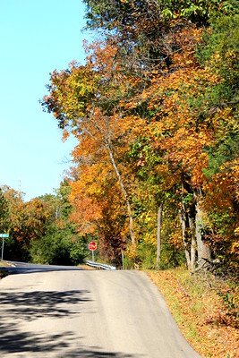
Missouri Route 86, designated the Ozark Highlands Scenic Byway, stretches approximately 110 miles through the Ozark Highlands south and west of Branson, Missouri. The route passes through Mark Twain National Forest and crosses the Long Creek arm of Table Rock Lake, offering uninterrupted views of dense hardwood forest, rolling hills, and open water.
Plan at least three hours for the full route, or drive a shorter out-and-back section starting from the Highway 86 junction near Blue Eye, about 20 minutes southwest of Branson. Gas stations are sparse past Kimberling City, so fill the tank before leaving. Route 86 is one of the few Ozark roads where the forest canopy closes overhead for miles at a stretch. During peak fall color in mid-October, the tunnel of maples and oaks along this byway turns red and gold from one horizon to the other.
How Do You Drive the Table Rock Lake Loop?
The Table Rock Lake Loop is an 8.4-mile route around the west side of Branson, Missouri, that crosses Table Rock Dam and passes through Table Rock State Park. The loop follows Highway 165 south from the dam area, turns west onto Highway 76 for about three miles, and then heads south on Indian Point Road toward marinas and lakeside pulloffs.
Start at the Table Rock Dam area, where free parking and an elevated walkway give drivers their first photo opportunity. Head west on Highway 76 for roughly three miles and turn south onto Indian Point Road. Follow Indian Point Road for about two miles through forested hills to reach cove overlooks, lake access points, and quiet spots for a roadside picnic.
Visitors who enjoy hiking alongside scenic driving can explore several outdoor trails and natural areas near Branson along this stretch of the Ozarks. Early mornings bring fog lifting off the water, and afternoon sun creates reflections across the surface that work well for wide-angle landscape photography.
What Can You See at Ruth and Paul Henning Conservation Area?
Ruth and Paul Henning Conservation Area is a 1,534-acre preserve on the west side of Branson, Missouri, managed by the Missouri Department of Conservation. The area features a wheelchair-accessible scenic overlook, a lookout tower, and 5.6 miles of hiking trails through upland oak and hickory forest and open Ozark glades.
The scenic overlook parking lot is on the east side of Highway 376, about three-quarters of a mile northwest from the intersection of Highway 376 and 76 Country Boulevard. Gates open at 8:00 AM daily, closing at 7:30 PM from mid-March through mid-October and 5:30 PM from mid-October through mid-March.
Paul Henning created The Beverly Hillbillies, Green Acres, and Petticoat Junction television series and donated much of this land to preserve the Ozark landscape that inspired his work. The 3.4-mile Homesteaders Trail includes 14 informational stops covering natural features and historical landmarks referenced in Harold Bell Wright’s novel The Shepherd of the Hills.
What Makes Historic Highway 76 a Different Kind of Branson Drive?
Historic Highway 76, known locally as “the Strip” or 76 Country Boulevard, runs through Branson’s main entertainment district and trades forest overlooks for neon theater signs, live music venues, and roadside Americana. The road stretches about three miles through the heart of Branson and connects most of the city’s major show theaters and family attractions.
Thousand Hills Resort Hotel is two blocks south of Highway 76, making the Strip a short drive or even a walkable evening destination after a full day of Ozark scenic touring. Photographers get the most out of Highway 76 at dusk, when theater lights switch on against a fading blue sky. Wet pavement after a rain shower adds reflections that double the neon effect.
The Strip also functions as a starting point for several scenic routes. Highway 165 branches south toward Table Rock Lake, and Highway 376 leads northwest to Ruth and Paul Henning Conservation Area. Guests heading to dinner at Jack Henry’s after a sunset drive along 76 Country Boulevard can be back at the hotel in under two minutes.
Where Is the Sugar Camp National Forest Scenic Byway?
The Sugar Camp National Forest Scenic Byway is a 28-mile drive through the Mark Twain National Forest, located about 45 minutes southeast of Branson near Cassville, Missouri. The route follows forest roads through wooded hills, high-elevation vistas, and stream-filled valleys before ending near Roaring River State Park.
This byway sees far less traffic than the Highway 165 loop and rewards drivers who prefer solitude and uninterrupted forest scenery. The road winds through dense oak and pine with occasional clearings that open into wide Ozark panoramas. Roaring River State Park at the southern end offers trout fishing, hiking trails, and one of Missouri’s largest natural springs.
Drivers who stay at Thousand Hills Resort Hotel and make the 45-minute trip to the Sugar Camp Byway’s starting point near Cassville should budget a full half-day for the round trip and allow time for a stop at Roaring River. Pack a lunch and plan for limited cell service, because there are no gas stations or restaurants along the byway itself.
When Is the Best Season for Scenic Drives Near Branson?
Peak fall foliage in the Branson, Missouri, area typically runs from mid-October through early November, when maples, oaks, and hickories turn the Ozark hills into layers of red, orange, and gold. Spring dogwood blooms appear in late March and April, and summer brings full green canopy with sparkling lake reflections across Table Rock Lake.
Thousand Hills Resort Hotel guests who visit during fall foliage season can start the morning with the complimentary Famous Breakfast Buffet, spend the day on the Route 86 Scenic Byway, and return in time for the full dining experience at the hotel’s three restaurants. The hotel’s indoor and outdoor heated pools stay open until 10:00 PM, so a post-drive soak is part of the routine.
Winter scenic drives have their own appeal. Bare branches open up views that dense summer foliage hides, and morning frost on the Ozark ridgelines creates a silver-and-blue palette that photographers rarely see in travel brochures. The roads between Branson and Table Rock Lake are nearly empty from December through February, so drivers can stop at overlooks without competing for pulloff space.
| Season | What to Expect | Best Routes |
|---|---|---|
| Spring (April to May) | Dogwood and redbud blooms, mild temps, clear skies | Table Rock Lake Loop, Henning Conservation Area |
| Summer (June to August) | Full canopy, lake reflections, warm afternoons | Highway 165 Overlook at sunrise, Sugar Camp Byway |
| Fall (mid-Oct to early Nov) | Peak foliage: red maples, gold oaks, crisp air | Route 86 Scenic Byway, Highway 165 loop |
| Winter (December to February) | Bare-branch silhouettes, misty mornings, uncrowded roads | Highway 76 at dusk, Henning Conservation Area |
What Photography Tips Work Best on Ozark Mountain Roads?
The Ozark Mountains around Branson, Missouri, produce their best photography light during the first and last hours of daylight, when low-angle sun adds depth to ridgelines and backlights fall foliage. Overcast days reduce harsh shadows and make greens and autumn colors appear more saturated in photographs.
1. Shoot into curves and leading lines. Ozark roads wind constantly, and the road itself creates natural composition. Position the road as a diagonal line from one corner of the frame to the opposite corner.
2. Use the Highway 165 Scenic Overlook guardrail as a camera rest. The elevated angle and open sky make it one of the steadiest handheld positions on any Branson scenic drive.
3. Tap to focus on the brightest part of the sky when shooting with a phone. The camera adjusts exposure downward, adding depth to shadows and bringing out cloud detail across the Ozark hills.
4. Visit the same overlook at different times. The Ruth and Paul Henning Conservation Area lookout tower shifts from warm golden morning light to cool blue-hour tones within a single day.
5. After rain, look for reflections on wet pavement along Highway 76. Neon signs reflected in puddles create some of Branson’s most distinctive photographs.
A trip to Branson that combines scenic Ozark drives with vacation packages bundling shows and accommodations makes the most of every season. Thousand Hills Resort Hotel guests returning from a full day behind the camera can grab coffee at Shiloh’s Marketplace before heading back out for golden-hour shots along Table Rock Lake.
Frequently Asked Questions
How far is the Highway 165 Scenic Overlook from downtown Branson?
The Highway 165 Scenic Overlook in Hollister is approximately five miles southwest of downtown Branson, Missouri, and takes about 10 minutes to reach by car from U.S. Highway 65.
Can you drive across Table Rock Dam?
Yes. Table Rock Dam is part of the Highway 165 and 265 loop near Branson, Missouri. Drivers cross the dam on Highway 165, with views of Table Rock Lake on one side and Lake Taneycomo on the other.
Is there an entrance fee for Ruth and Paul Henning Conservation Area?
No. Ruth and Paul Henning Conservation Area in Branson, Missouri, is free and open to the public year-round. The scenic overlook parking area opens at 8:00 AM daily.
How long does the Highway 165 scenic loop take to drive?
The 22-mile Highway 165 and 265 loop takes approximately 40 minutes by car without stops. Allow 90 minutes to two hours with photo stops at the overlook, Table Rock Dam, and Table Rock State Park.
What is the best month to see fall colors in the Ozarks near Branson?
Peak fall foliage in the Ozark Mountains around Branson, Missouri, typically occurs from mid-October through early November. Maples turn first, followed by oaks and hickories.
Where can you see the best views of Table Rock Lake?
The Highway 165 Scenic Overlook provides the most accessible panoramic view of Table Rock Lake, Table Rock Dam, and the surrounding Ozark hills. The Ruth and Paul Henning Conservation Area lookout tower offers a broader 360-degree view of the Branson area.
Is Inspiration Tower at Shepherd of the Hills open to visitors?
Inspiration Tower at the Shepherd of the Hills attraction in Branson stands 230 feet above the Ozark hills and is open daily. Spring and summer hours begin at 9:00 AM, and winter hours run 10:00 AM to 4:00 PM, weather permitting.
How far is the Sugar Camp Scenic Byway from Branson?
The Sugar Camp National Forest Scenic Byway begins about 45 minutes southeast of Branson near Cassville, Missouri. The 28-mile route ends near Roaring River State Park.
What scenic byways are within driving distance of Branson Missouri?
Branson, Missouri, sits within reach of several designated scenic routes, including the Ozark Highlands Scenic Byway on Missouri Route 86 (110 miles), the Sugar Camp National Forest Scenic Byway (28 miles near Cassville), and the Highway 165 and 265 loop (22 miles around Table Rock Lake).
Does Thousand Hills Resort Hotel have a good location for scenic drives?
Thousand Hills Resort Hotel is two blocks off Highway 76 in Branson, Missouri, placing the Highway 165 Scenic Overlook, Table Rock Lake Loop, and Ruth and Paul Henning Conservation Area within 15 minutes of the hotel. The complimentary Famous Breakfast Buffet makes early-morning departures for Branson scenic overlook photos.
Ready to turn Branson’s scenic drives into a weekend escape? Visit thousandhillsresorthotel.com or call (877) 815-0990 to reserve your room at the guaranteed best rate. The front desk team can help arrange show tickets, golf tee times at the adjacent Thousand Hills Golf Course, and vacation packages before you arrive.